36
FLAMMARION. Carte générale de la lune.
1877
EUR 2.500,00
Base d'asta
EUR 4.000,00 / 5.000,00
Stima
Descrizione
FLAMMARION. Carte générale de la lune.
1877
1877
FLAMMARION, Camille. Carte générale de la lune/dressée sous la direction de Camille Flammarion; par C.-M. Gaudibert; dessinée par Léon Fenet.
Paris, Emile Bertaux, 1877
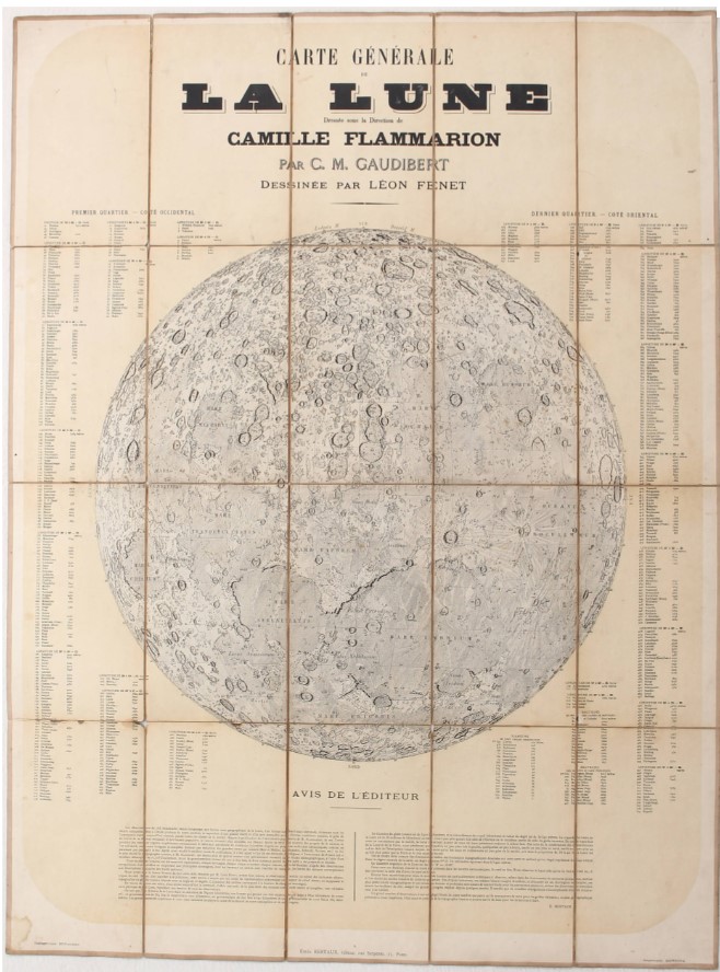
Carta murale di grande formato impressa in fotoincisione a colori. 115 x 855 cm. Montata su tela, in 20 segmenti pieghevoli. In alto al centro titolo e nome degli autori, lungo i lati le indicazioni con 509 toponimi. In basso, sul margine, iscrizioni tipografiche: a sinistra “Heliogravure Dujardin”; al centro “Emile Bertaux, Paris”; a destra “Imprimerie Monrocq”. Lieve brunitura, qualche lieve difetto nei punti di intersezione dei segmenti, piccolo strappetto in basso a sinistra, in complesso buono stato di conservazione.
Rarissima carta della Luna. Mappa molto accurata, progettata sotto la supervisione del grande astronomo Camille Flammarion e realizzata dal disegnatore Léon Fenet in base alle indicazioni dell’astronomo Casimir Marie Gaudibert. La mappa rappresenta il satellite della Terra e il suo particolarissimo rilievo come erano conosciuti dagli astronomi alla fine del XIX secolo. La Luna è riprodotta con il nord verso il basso, secondo l'orientamento osservato con il telescopio astronomico. Diviso in quattro quarti, il disegno di Léon Fenet evidenzia nel dettaglio i principali siti lunari, dai mari Tranquillità e Imbrium all'immenso cratere di Copernico, senza dimenticare le notevoli ripide montagne dei Monti Riphaeus. Sono raffigurati, con i loro nomi e la longitudine, i 509 crateri lunari.
La carta fu edita dall’astronomo Émile Bertaux, specializzato nella pubblicazione di planisferi, carte selenografiche della luna e del pianeta Marte; Bertaux scrive la nota esplicativa posta sotto l’immagine.
Nonostante fosse un astronomo dilettante, Gaudibert fu elogiato per la precisione delle sue osservazioni, che durarono oltre 15 anni. La sua fama si estese quando Bertaux, l'editore di questa mappa, creò un globo lunare dai suoi dati. In suo onore è stato dato il suo nome a un cratere.
L’eccellente resa grafica della carta è opera del celebre fotografo e incisore Paul Rodolphe Joseph Dujardin, 1843 – 1913. Princeton University: “Dujardin used his own secret variation of heliogravure (French for photogravure) to transfer each paper print to a new copper printing plate, which was then etched and printed.”
Un esemplare presso la BNF, http://catalogue.bnf.fr/ark:/12148/cb40718002h.
Bibliografia: Sheehan/ Dobbins. Epic Moon. A history of lunar exploration, pp. 197/198; Manasek, A Treatise on Moon Maps, S. 326 ("Carte géographique de la lune"); Zögner, Die Welt in Händen, S. 40 (Mondglobus).
Cfr. Paul Dujardin, in ‘Special Collections, Firestone Library, Princeton University’: https://graphicarts.princeton.edu/2017/11/29/paul-dujardin-1843-1913/
Condition Report
Large size wall map printed in color photogravure. 115 x 855 cm. Mounted on canvas, on 20 folding segments. Title and name of the authors at the top center, along the sides the indications with 509 toponyms. At the bottom, in the margin, typographic inscriptions: on the left "Heliogravure Dujardin"; in the center "Emile Bertaux, Paris”; on the right "Imprimerie Monrocq". Slight browning, some slight defects at the intersection points of the segments, small tear at the bottom left, in overall good condition.
Extremely rare map of the Moon. Very accurate map, designed under the supervision of the great astronomer Camille Flammarion and created by the designer Léon Fenet based on the indications of the astronomer Casimir Marie Gaudibert. The map represents the Earth's satellite and its very particular relief as they were known to astronomers at the end of the 19th century. The Moon is shown with north down, as seen through an astronomical telescope. Divided into four quarters, Léon Fenet's drawing highlights in detail the main lunar sites, from the Sea of Tranquillity and Mare Imbrium to the immense Copernicus crater, not forgetting the remarkable steep mountains of Montes Riphaeus. The 509 lunar craters are depicted, with their names and longitude.
The map was edited by the astronomer Émile Bertaux, who specialized in publishing planispheres, selenographic maps of the Moon and the planet Mars; Bertaux wrote the explanatory note below the image.
Despite being an amateur astronomer, Gaudibert was praised for the precision of his observations, taking over 15 years. His fame was extended when Bertaux, the publisher of this map, created a lunar globe from his data. A crater on the Moon has been named in his honour.
The excellent graphic rendering of the map the work of the famous photographer and engraver Paul Rodolphe Joseph Dujardin, 1843 – 1913. Princeton University: “Dujardin used his own secret variation of heliogravure (French for photogravure) to transfer each paper print to a new copper printing plate, which was then etched and printed.”
A specimen at the BNF, http://catalogue.bnf.fr/ark:/12148/cb40718002h
References: Sheehan/ Dobbins. Epic Moon. A history of lunar exploration, pp. 197/198; Manasek, A Treatise on Moon Maps, S. 326 ("Carte géographique de la lune"); Zögner, Die Welt in Händen, S. 40 (Mondglobus).
Cfr. Paul Dujardin, in ‘Special Collections, Firestone Library, Princeton University’: https://graphicarts.princeton.edu/2017/11/29/paul-dujardin-1843-1913/
mar 11 Febbraio 2025
Orari Asta
Via dei Soncin, 28
35122 Padova
ESIBIZIONE: 6-8 Febbraio 2024 solo su appuntamento.
ESIBIZIONE: 6-8 Febbraio 2024 solo su appuntamento.

