121
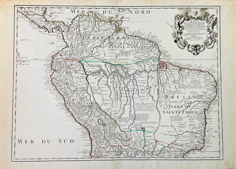
South America. DE L'ISLE. Carte de la Terre Ferme du Perou, Du Bresil et du Pays des Amazones.
EUR 350,00
Base d'asta
EUR 500,00 / 600,00
Stima
Descrizione
South America. DE L'ISLE. Carte de la Terre Ferme du Perou, Du Bresil et du Pays des Amazones.
DE L'ISLE, Guillaume. Carte de la Terre Ferme du Perou, Du Bresil, et du Pays des Amazones Carte du Paraguay du Chili du Detroit De Magellan & c.
Paris, 1703
Incisione in rame mm.483x 652; coloritura d’epoca. Interessante carta geografica con bel cartiglio in alto a destra. Margini. Due pregiate filigrane, tra cui una Croce di Malta incorniciata da un rosario. Bell’esemplare.
Rara mappa di De L'Isle della parte settentrionale del Sud America. Questa mappa del Sud America è molto dettagliata e accurata, ricca di annotazioni e include i percorsi degli esploratori europei del XVII secolo.
De L'Isle era noto per il suo raffinato stile di mappatura scientifica, limitando il contenuto cartografico delle sue mappe a quelli che considerava rapporti affidabili ed eliminando le informazioni speculative. Attraverso un meticoloso processo di confronto dei rapporti provenienti da più fonti, è stato in grado di riconciliare dati diversi per creare le migliori mappe del periodo.
Il dettaglio del Rio delle Amazzoni e dei suoi affluenti è piuttosto avanzato per il periodo, così come il trattamento delle Ande.
Guillaume De L'Isle (1675-1726) è probabilmente la più grande figura della cartografia francese. Avendo imparato la geografia da suo padre Claude, all'età di otto o nove anni poteva disegnare mappe per dimostrare la storia antica. Studiò matematica e astronomia sotto Cassini, dal quale ricevette una superba preparazione in cartografia scientifica, il segno distintivo del suo lavoro. Il suo primo atlante fu pubblicato nel ca. 1700. Nel 1702 fu eletto membro dell'Académie Royale des Sciences e nel 1718 divenne Premier Geographe du Roi. Si può giustamente dire che fu veramente il padre della moderna scuola di cartografia.
Condition Report
Engraving of 483x652 mm, contemporary coloring. First state. Nice cartouche on the top right. Margins. Two fine watermarks, including a Maltese Cross framed by a rosary. Nice specimen.
Rare De L'Isle map of the northern part of South America. This map of South America is highly detailed and accurate, annotated, and includes the routes of 17th-century European explorers.
De L'Isle was known for his refined style of scientific mapping, limiting the cartographic content of his maps to what he considered reliable reports and eliminating speculative information. Through a meticulous process of comparing reports from multiple sources, he was able to reconcile disparate data to create the best maps of the period.
The detail of the Amazon and its tributaries was advanced for the period, as well as the treatment of the Andes.
Guillaume De L'Isle (1675-1726) is probably the greatest figure in French cartography. Having learned geography from his father Claude, at the age of eight or nine he could draw maps for ancient history. He studied mathematics and astronomy under Cassini, from whom he received a superb training in scientific cartography, the hallmark of his work. His first atlas was published in ca. 1700. In 1702 he was elected a member of the Académie Royale des Sciences and in 1718 he became Premier Geographe du Roi. It can be rightly said that he was truly the father of the modern school of cartography.
mar 11 Febbraio 2025
Orari Asta
Via dei Soncin, 28
35122 Padova
ESIBIZIONE: 6-8 Febbraio 2024 solo su appuntamento.
ESIBIZIONE: 6-8 Febbraio 2024 solo su appuntamento.

